Guest post: Twenty years of AERONET-OC provision of ocean colour calibration and validation data

Long term operation of network supporting the validation of satellite ocean colour observations contributing to the quantification of these natural ‘sinks’ of carbon.
Marking the twentieth anniversary of the Ocean Colour component of the Aerosol Robotic Network (AERONET-OC), Frédéric Mélin, of MetEOC-4 External Funded Partner JRC, summarises ‘fruitful encounters’ between the AERONET-OC ocean colour network and MetEOC projects.
But first, some background.
An objective of the MetEOC series of projects is to develop satellite derived SI-traceable measurement methods to measure greenhouse gases emissions and carbon sinks. The context for that requirement is that knowledge of the amounts of greenhouse gases absorbed by such sinks will be a critical part of the equation for any workable net zero strategy.
Currently, the earth’s oceans act as the largest carbon ‘sink’; absorbing about a quarter of all emitted CO2, mostly due to photosynthesis by phytoplankton. This carbon is then sequestrated via the food chain into the ocean environment.
As clusters of phytoplankton reflect sunlight differently to pure sea water, measurements of this reflectance change, known as ocean colour, can be related to carbon absorption.
Ocean colour can be remotely measured from space by removing the atmospheric contribution to the signal received by the sensor in orbit. In-situ observations, besides their applications for environmental monitoring, are used for making comparisons with satellite observations; this process, termed validation, is key to assessing the quality of satellite data. In-situ data can also support improved characterizations of space sensors through a process called system vicarious calibration.
Measurements at ensembles of well-controlled sites offer geographically-distributed, and comparable, data. AERONET (AErosol RObotic NETwork) is one such network; a long running federation of ground-based remote sensing aerosol networks established by NASA and PHOTONS (PHOtométrie pour le Traitement Opérationnel de Normalisation Satellitaire; Univ. of Lille 1, CNES, and CNRS-INSU). – expanded by collaborations from national agencies, institutes, universities, individual scientists, and partners.
This network provides a long-term, continuous, and readily accessible public domain database of aerosol optical, microphysical, and radiative properties for aerosol research and characterization, validation of satellite retrievals, and synergies with other databases.
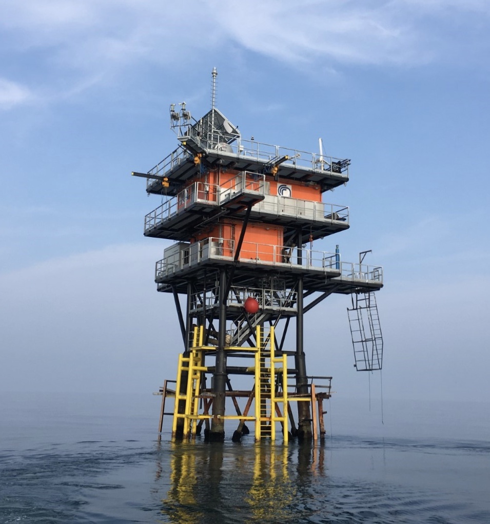
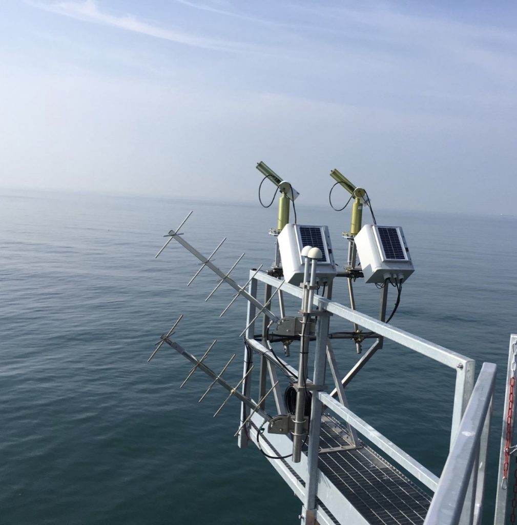
The AERONET component Ocean Color (AERONET-OC) provides sea radiance data (i.e., water-leaving radiance) with CE-318 sun-photometers installed on offshore platforms such as lighthouses, oceanographic and oil towers. AERONET-OC supports the validation of satellite ocean colour activities through standardised measurements performed at different sites with a single measuring system and protocol, calibrated with an identical reference source and method, and processed with the same code.
It provides, for example, radiometric data for validating the European missions Sentinel-3A&B and Sentinel-2A&B, and other missions with a water/surface reflectance product, including MODIS and VIIRS.
Since 1998, Frédéric Mélin has worked for the Joint Research Centre (JRC), European Commission, Ispra, Italy. His research focuses on the determination of atmospheric and marine optical properties based on optical remote sensing and the determination of their uncertainties. Other research interests include the use of satellite data, with an emphasis on ocean colour, together with models, for the study of marine biogeochemical cycles.
The JRC provides independent, evidence-based knowledge and science, supporting EU policies to positively impact society.
Here, Frédéric summarises the refinements made to metrological practices of AERONET-OC resulting from the ongoing collaborative research partnerships with MetEOC.
—
AERONET-OC – the main source of data for the validation of ocean colour satellite observations
By Frédéric Mélin
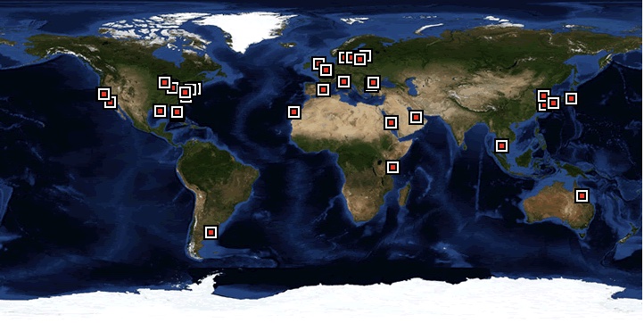
In 2022 we celebrated the twentieth anniversary of the operations of the Ocean Colour component of the Aerosol Robotic Network (AERONET-OC). Since the initial measurements in 2002, the network has grown steadily to encompass 39 sites distributed world-wide (of which 25 were active in 2022) and is now the main source of data for the validation of ocean colour satellite observations.
AERONET was born at the end of the 1990s to collect autonomous measurements of aerosol optical properties with sun photometers (Holben et al. 1998). Later, in the context of a collaboration between the US National Aeronautics and Space Administration (NASA) and the Joint Research Centre (JRC) of the European Commission, the measurement protocol was extended to include the capability of determining the radiance emerging from the sea (or water-leaving radiance) from suitable off-shore structures (Zibordi et al. 2002).
The first marine measurements took place in April 2002 at the site of the Acqua Alta Oceanographic Tower (AAOT) located in the North Adriatic Sea. In the following years, additional sites became operative and constituted AERONET-OC (Zibordi et al. 2006, 2021). Since then, AERONET-OC has provided globally distributed standardized measurements of water-leaving radiance associated with aerosol optical properties that are available to the community in near-real time (https://aeronet.gsfc.nasa.gov).
Today, AERONET-OC is a major source of data for the validation of satellite ocean colour products, in addition to providing a unique time series of aquatic surface optical properties, mostly for coastal and in-land waters.
Refining reference data by explicit reference to Metrological principles
Providing autonomous standardized measurements that can be considered as reference data for the validation of satellite products requires an appropriate measurement protocol and associated quality control (Zibordi et al. 2022).
From the inception of AERONET-OC, particular attention was devoted to the calibration and characterization of the instruments, the quality control of the data and the determination of their uncertainties.
METEOC-1 was an opportunity to refine the latter with explicit reference to metrologically-based practices, an effort continued in subsequent METEOC projects (Cazzaniga & Zibordi, 2023).
METEOC-3 and METEOC-4 provided the resource to improve the metrological rigour of the validation of the satellite data, i.e., the comparison of satellite products with reference field measurements. In addition to detailed analysis of the protocol used to select data considered suitable for a meaningful comparison, methods have also been proposed to interpret validation statistics in terms of satellite data uncertainties considering the uncertainties associated with the field data as well as those due to representativity errors (e.g., satellite and field data having different scales and times of acquisition) (e.g., Mélin 2021).
AERONET-OC on metrologically-solid ground
These developments were made possible by the large amounts of field data available after 20 years of operations and which also represent a large diversity of optical water types. The collaborative partnership between AERONET-OC and METEOC proved a fruitful encounter: that should place the continuation of the AERONET-OC operations and the exploitation of the resulting data on metrologically-solid ground for the future.
References
- Cazzaniga, I., G. Zibordi, ‘AERONET-OC LWN uncertainties: revisited’, J. Atmos. Ocean. Tech., in press, 2023.
- Holben, B.N., T.F. Eck, I. Slutsker, D. Tanré, J.P. Buis, A. Setzer, E. Vermote, J.A. Reagan, Y.J. Kaufman, T. Nakajima, F. Lavenu, I. Jankowiak, A. Smirnov, ‘AERONET – A federated instrument network and data archive for aerosol characterization’, Remote Sens. Environ., 66, 1-16, 1998.
- Mélin, F., ‘From validation statistics to uncertainty estimates: Application to VIIRS ocean color radiometric products at European coastal locations’, Frontiers Mar. Sci., 8, 790948, 2021.
- Zibordi, G., S.B. Hooker, J.-F. Berthon, D. D’Alimonte, ‘Autonomous above-water radiance measurements from an offshore platform: A field assessment experiment’, J. Atmos. Ocean. Tech., 19, 808-819, 2002.
- Zibordi, G., B.N. Holben, S.B. Hooker, F. Mélin, J.-F. Berthon, I. Slutsker, D. Giles, D., Vandemark, H. Feng, K. Rutledge, G. Schuster, A. Al Mandoos, A., ‘A network for standardized ocean color validation measurements’. EOS Trans. Am . Geophys. Union, 87, 30, 293, 297, 2006.
- Zibordi, G., B.N. Holben, M. Talone, D. D’Alimonte, I. Slutsker, D.M. Giles, M.G. Sorokhin, ‘Advances in the Ocean Color component of the AerosolRobotic Netwrok (AERONET-OC)’, J. Atmos. Ocean. Tech., 38, 725-746, 2021.
- Zibordi, G., D. D’Alimonte, T. Kajiyama, ‘Automated quality control of AERONET-OC LWN data’, J. Atmos. Ocean. Tech., 39, 1961-1972, 2022.
—
Postcript: MetEOC contributions to Aeronet-OC
- Within MetEOC-1, analysis and optimisation of methods used to provide traceability of the Aeronet-OC network led to a documented best practise guide and a reduction in the radiometric component of the uncertainty by a factor of two.
- Within MetEOC-3, JRC evaluated the linearity of a range of commercially available radiometers both multi- and hyper-spectral.
- In MeteOC-4:
- JRC together with NPL addressed uncertainties associated with ocean colour algorithms of atmospheric correction, particularly those due to meteorological data (papers published: Sensitivity of Ocean Color Atmospheric Correction to Uncertainties in Ancillary Data: A Global Analysis With SeaWiFS Data and Ancillary Data Uncertainties within the SeaDAS Uncertainty Budget for Ocean Colour Retrievals)
- Guidelines are currently being developed on how to assess uncertainties of ocean colour measurements. AERONET-OC field data was compared to data from the VIIRS-JPSS1 and VIIRS-SNPP satellites, with early results indicating consistency within uncertainty budgets. See: Mélin, F., ‘From validation statistics to uncertainty estimates: Application to VIIRS ocean color radiometric products at European coastal locations’, Frontiers Mar. Sci., 8, 790948, 2021.).